| [ | Home | | | Facilities | | | Routes | | | Ideas | | | Precincts | | | Transport | | | Signs | | | Commentary | | | Videos | | | Links | ] |
Firstly I am listing some ideas about the cycle networks in the Strathclyde area. Below that are some older ideas of mine.
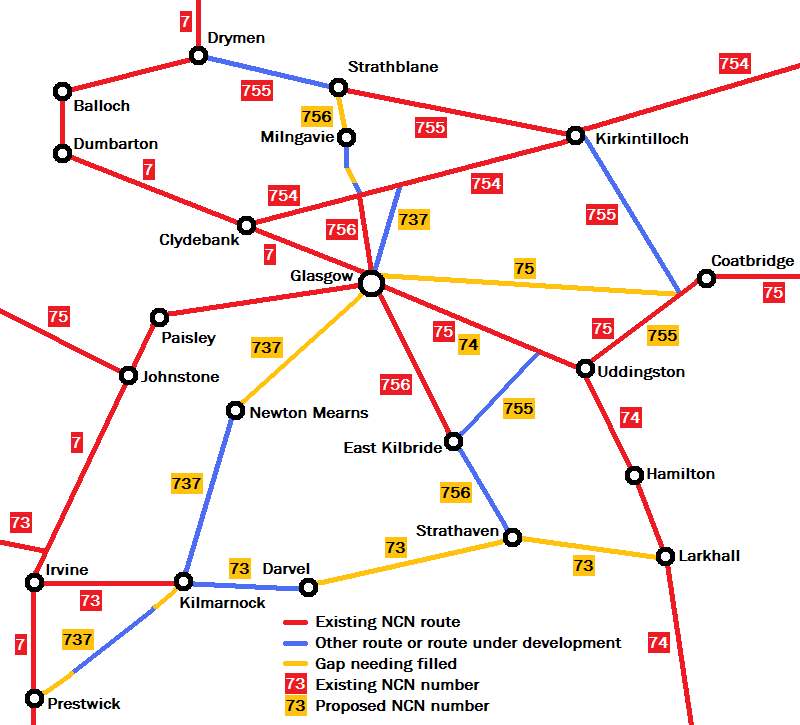
At the moment, the National Cycle Network routes around the Glasgow area form a rather sparce network of routes. Indeed there are more motorways within Glasgow's boundaries than NCN routes. But once outside of Glasgow, these routes see very little interaction with other NCN routes, so don't form much of a network for much of the population. However, there are a handful of other longer-distance routes which could be brought into the National Cycle Network, and indeed Sustrans has already allocated an NCN number to the Strathkelvin Railway Path as well as proposing extensions to link in with other NCN routes. The map above shows my ideas for the development of the network, and is not endorsed by anyone else. The main features are:
A network of routes was signed in Cumbernauld consisting of five main routes and a number of connecting subsidiary routes. An early version of the diagrammatic map of the network can be found on flickr.
I think it would be more straight forward to eliminate the route numbers with suffixes, and replace them with a network of eight routes, each of which has a purpose such as going to the town centre or to one of the town's main railway stations. I have also suggested some extensions to reach parts of the town that are currently without a connection to the network. Routes 1 to 4 all pass through the town centre, and routes 5 to 8 serve the fringes of the town, including the railway stations. Some routes share common sections, so would be jointly signed (as happens inconsistently at present).
| Route No. | Proposed Terminus | South/West extension | Existing Terminus | South/West route | Via | North/East route | Existing Terminus | North/East extension | Proposed Terminus |
|---|---|---|---|---|---|---|---|---|---|
| 1 | Auchinstarry | Existing route 1 rerouted between Croy & Auchinstarry | Croy Station Town Centre Cumbernauld Station |
Existing route 1 | Palacerigg | ||||
| 2 | Strathkelvin Path | Mollinsburn/Stoneyetts completing M80 path | Condorrat | Existing route 2 | Town Centre | Existing route 2 diverted via Kildrum & Vault Glen | Abronhill | St Lucy's | Whitelees |
| 3 | Cumbernauld Rugby Club | Cumbernauld Rugby Club via replaced steps at Chapelton Road | Ravenswood | Existing route 3/1e to Auchenkilns Holdings | Town Centre | Existing route 3 | Abronhill | Could swap route beyond Cumbernauld Glen with Route 7 | |
| 4 | Hunt Hill | Hunt Hill via upgraded B8048 footway | Broadwood | Existing route 1/1b/4a to Blackwood | Town Centre | Existing route 2/2a | Palacerigg | ||
| 5 | Condorrat | Existing route 4 | Croy Station | Existing route 5/1a to Dullatur Roundabout | Dullatur | ||||
| 6 | Condorrat | Collingwood/Westfield/Kirk Place | Broadwood | Existing route 4a to Blackwood | Croy Station | Existing route 1/1a to Dullatur Roundabout | Dullatur | Eastfield Road or a new M80 footbridge/Cumbernauld Village | Cumbernauld House |
| 7 | Dalshannon | Existing route 1f | Cumbernauld Station | Existing route 1/Carbrain Primary/Existing route 3a | Cumbernauld Theatre | Cumbernauld Glen/Wardpark/Cumbernauld Airport | Wyndford Lock | ||
| 8 | Blairlinn | Existing route 1d | Cumbernauld Station | Existing route 1c/2 to Abronhill | Abronhill | Birch Road/Maple Court | Whitelees |
The network would thus provide more connections with National Cycle Network routes (at Stoneyetts, Auchinstarry and Wyndford Locks) and more comprehensive coverage of the town, without any need for suffixed route numbers. Most of the extensions are on existing paths, some of which would need upgrading.
| [ | Glasgow East - Coatbridge | | | Coatbridge - Strathclyde Park | ] |
(Note that the proposals below are now out of date and various changes to routes have since happened)
These three routes should not be considered as different options for one final route. Instead they can all be developed together, with each route serving a different market. The first is intended as a 24-hour route, usable night and day, whilst the others are aimed more at the leisure market. Each route makes better use of existing infrastructure, with only a limited amount of new build. The second two have substantial common sections, and can be developed together.
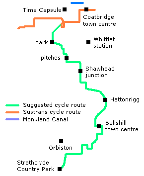
This route provides a direct link between Coatbridge and Strathclyde Park, via Bellshill. There are already plans for a link between the Sustrans cycle route at Uddingston and Strathclyde Park, but this is a rather long way round to get from Coatbridge to the park. Similarly it is possible to go from Coatbridge along the Monkland Canal to Calderbank, then through Eurocentral and Holytown, but again going via Bellshill is more direct. The route makes extensive use of existing minor side streets, many of which already have "Twenty's Plenty" advisory speed limits, and some existing paths through parks. The major issue here is how to get through Shawhead Junction, where the A725, B7070 and A8 meet up, creating a hellish roadscape for the would-be law-abiding cyclist.
| [ | Glasgow East - Coatbridge | | | Coatbridge - Strathclyde Park | ] |
| [ | Home | | | Facilities | | | Routes | | | Ideas | | | Precincts | | | Transport | | | Signs | | | Commentary | | | Videos | | | Links | ] |