Cycle Routes Ideas
Cranhill - Coatbridge: direct leisure & commuting route
Only part of this route is lit, so it cannot be considered as a 24-hour cycle route. The route uses the under-used Monkland Canal for much of its length, and the link within Glasgow comprises mostly paths and little used roads.
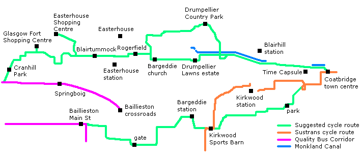
This route starts at Cranhill Park. It follows Bellrock Street into Blairtummock Road, then via Horndean Crescent to the path alongside the M8 motorway. This path passes the Glasgow Fort shopping centre and leads to Bartiebeith Road, from where Baldovan Crescent leads to Baldovan Path, alongside Wellhouse Road. On the other side of the main road, Wellhouse Path leads to Ware Road. From here, Halliburton Road leads to a footbridge across the motorway connecting to Kildermorie Road. Sword Place then makes a neat little link to a path under Wardie Road into Blairtummock Park. There is an alternative connection from the Easterhouse Shopping Centre via Shandwick Street and Kildermorie Road to Struie Street, then uses the path under Wardie Road and into the park.
 The path through the park runs adjacent to the motorway so is a bit noisy, but it is direct. Perhaps an embankment could be formed between the path and the motorway, as has been done in part at one end, to shield the path, and the park, from the noise. At the far end, the route crosses Easterhouse Road, adjacent to the motorway junction. This is a moderately busy road, but a Toucan Crossing could be provided here simply by signalising the junction between Easterhouse Road and the motorway sliproad. The route continues straight on into Rogerfield Road.
 Rogerfield Road is a bizarre road. At its eastern end it is a tranquil country lane, but nearer the western end it is a rubbish tip! This needs dealt with. Since very little motorised traffic, other than that involved with fly-tipping, uses this road, it could be closed between Easterhouse Road and Rogerfield Farm, and turned into a cycle path. Thus barriers could prevent vehicles getting to the fly-tipping site (no fly-tipping occurs at the ends of the road, only in the central section) and they could go elsewhere. There is a small area of forestry adjacent to the western end of the road, so this would be complimented by a revamp of the road from its current disgraceful state.
 Rogerfield Road further east, which becomes Denmilne Road, is much nicer! There is no reason why measures cannot be put in place to prevent access to the fly-tippers and allow the rest of the road-users to enjoy the full potential of this much-abused road. (Contact Glasgow City Council by telephone on 08000 277 027 to report incidents of fly-tipping, in the hope that it will get cleared up. Even better, if you see someone fly-tipping, get the registration number of any motor vehicle used and report this too. Call 0845 230 4090 to report fly-tipping anywhere in Scotland, or 0800 555 111 for Crimestoppers.)
 At the end of Denmilne Road, the route turns right into Netherhouse Road, crosses the dried up course of the Monkland Canal, then turns left into Manse Road. At this point it passes the church at Bargeddie - a local landmark - before running alongside a railway line and under a motorway. At the end of Manse Road the route meets the A752.
 Just as with the other routes, crossing the A752 is a bit of a problem. The junction with Manse Road is not very far from the A89/A752 junction so the traffic is not going terribly fast, so it would be possible to provide a Toucan Crossing, and possibly extend the 30mph limit to this point (theres a nursery at this end of Manse Road too), to allow cyclists to get to the other side. Once across, a path could be formed into the new Drumpellier Lawns housing development, linking to Maple Grove. From here Cherryridge Drive leads through the estate to Oakridge Road which forms the motorists' entrance to the estate.
 To link to the Monkland Canal, which is located behind the new housing estate, a new path has now been constructed. Once on the canal, the path continues right through to Coatbridge town centre.
 The towpath on the western section of the Monkland Canal has been upgraded between Drumpellier Lawns and Coatbridge. This is even signed with cycle route signs, and links with Drumpellier Country Park. The nature of the canal changes as it approaches Coatbridge, entering first an urban park, then after the canal becomes culverted, merely a path through some open space in front of some housing.
 It would be nice for the canal to be extended into Coatbridge once again, to join with the "pond" in the town centre. However, that is outwith the scope of these pages. However, the route of the canal is now utilised by a cycle path connecting the western section of canal with the town centre. The path ends up at the railway bridges, from where there is a pedestrian crossing across Bank Street to the Sustrans route. The Sustrans route joins the route of the canal further east for a short distance, before switching to a former railway line to continue to Airdrie.
Now you've arrived, select another route in this series:
 The path through the park runs adjacent to the motorway so is a bit noisy, but it is direct. Perhaps an embankment could be formed between the path and the motorway, as has been done in part at one end, to shield the path, and the park, from the noise. At the far end, the route crosses Easterhouse Road, adjacent to the motorway junction. This is a moderately busy road, but a Toucan Crossing could be provided here simply by signalising the junction between Easterhouse Road and the motorway sliproad. The route continues straight on into Rogerfield Road.


